 Ted waits at Largs for the Cumbrae Ferry
A free day in Glasgow in September 2018 before heading home to Durham in the evening led to a plan to take a day trip to somewhere new. When I looked at the map I realised that I had never been the to the island of Great Cumbrae in the Firth of Clyde, despite it being the easiest island to reach from Glasgow. So Ted and I set off in the footsteps of millions of Glaswegians who used to head doon the watter for their summer holidays on the Costa del Clyde.
 The first stage in the journey to Cumbrae and its only town Millport is the train journey from Glasgow Central to Largs. I visited Largs several times in the 1970s, but hadn’t travelled beyond Ardrossan since then. Past Ardrossan the villages en route look much the same as they always did – rather twee commuter and retirement settlements with a bit of tourism thrown in. When I checked later West Kilbride is making a name for itself as a craft town and neighbouring Seamill attracts tourists to the Hydro (Hydropathic Hotel) and the sands . Fairlie station used to be known as Fairlie High until the pier station was closed in 1971. It remains topographically accurate as it is above the village – there are classic raised beaches along this coastline and the railway follows one. I vaguely remember a nice pub in Fairlie, which may still be there. 2025 update: The Village Inn is still there, it is in the Good Beer Guide, and Ted and I spent a pleasant hour in the public bar in April 2025. We also had a pint in and can recommend the Twa Dugs in West Kilbride. Both can be visited as part of a day trip to Largs and/or Millport.
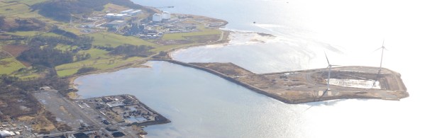
The fortunes of the Hunterston peninsula (above), between Seamill and Fairlie are a microcosm of Scottish industry over the last forty years. Hunterston A nuclear power station was already there when I last passed by, closed in 1990 and is now decommissioned. Hunterston B was under construction and will remain in operation until 2023/4, depending how many more cracks are found on the reactors. An oil rig construction yard opened for a few years in 1978. The site was then used to build a dry dock for Trident submarines and a Gravity Base Tank (No, I don’t know –it is something to do with the oil industry) before closure in 1996. The Hunterston deep water jetty and port opened in 1979 to import iron ore for Ravenscraig steelworks. After the closure of the works the port was used to import coal for Longannet (closed) and Drax (now mainly biomass) power stations. It is now derelict together with all the associated railway branches and yards, the coal unloaders are being demolished, and no further use has been found. The picture above is from Peel Ports, the current owner, which is trying to market the site (see note 1).
 Largs station 1995
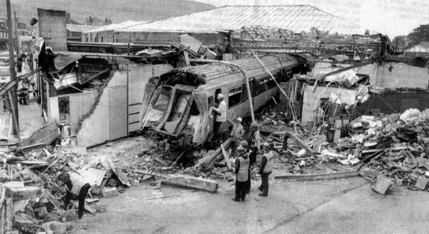
Largs station is a shadow of its former self – much of it was demolished in 1995, when a train forgot to stop at the buffers and headed for the main street – amazingly no-one was seriously injured or killed. From the station it is a short walk down Main Street to the Cumbrae Ferry. The train is perfectly timed so that the ferry pulls out just as you arrive at the slipway. However, there is another in 30 minutes, and time for a very quick look round town.
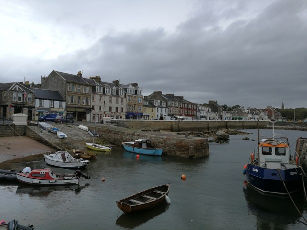
Largs is a bustling little town of about 11,000 people. In the past it was a holiday resort for Glaswegians and is still a day-trip destination. It is also used as a base for English coach parties visiting the region. Its situation by the Firth makes it attractive to commuters and for retirement living. The seafront remains familiar from the 1970s. The church where friends were married is still there as is Nardini’s café, a Largs institution since the 1930s in a superbly restored art deco building. Nowadays, by the ferry slipway there is a Wetherspoon’s pub and a Co-op shop, for people to stock up before heading for Millport. I can’t remember any of the pubs in town from my previous visits, though no doubt we were in one or two. 2025 update: In April 2025 we called in at the Three Reasons, close to the ferry slipway – most people were eating but the beer was good.
 Nardini’s cafe, Largs
The Calmac ferry from Largs takes less than ten minutes to reach Cumbrae Slip, situated at the closest point on the island. There is just enough time to take Ted up to the top deck to have a look at the scenery and wonder when the rain is going to start (it didn’t). It is well used by islanders shopping and commuting to school and work on the mainland, as well as by day-trippers to the island. A bus meets every ferry and takes ten minutes or so to reach the not-exactly-teeming metropolis of Millport – it seems that most islanders are off to Largs for the day as I hardly see a soul under the age of sixty.


The Loch Shira arrives (left) and sets off (top right) from Largs, and arrives at Cumbrae Slip (bottom right)
The town is mainly one long street round Millport Bay, lined with attractive stone villas, and tenements, dating from its heyday in the Victorian and Edwardian period. Like Largs, Millport was a holiday resort for Glaswegians. Today most tourists are day-trippers, though we spot quite a few holiday lets. It appears that many people have retired to the island and I hear English as well as Scottish accents among them. There is not much recent development that I can see (but it could be hidden away from the seafront). There are a few everyday shops, cafes, gift shops, two chip shops and a Chinese restaurant, though from the bags people were carrying on the ferry most people head to the mainland for supermarket shopping. There are several bike hire places – round the island is a fairly easy 10 mile ride. My brother remembers cycling around with my mother, but I must have left home by then. I found Millport (below) attractive with a pleasant feel to it – this probably shows my age. Like any island it could be claustrophobic but the frequent ferry and nearby mainland means that escape is easy when necessary.
Obviously, the town and the island depend on the piers for access. It turns out that the ferry slipway was previously the Tattie Pier, used for exporting potatoes from the island by puffer, then reconstructed in 1971 to allow a frequent car ferry service. Frequent steamer services in its heyday meant two piers were necessary in town, though they haven’t been regularly used for many years. Millport Pier is largely disused and currently the focus of a campaign to save it. The paddle steamer Waverley calls in summer at Keppel Pier, on the road into town, next to a Field Studies Centre specialising in Marine Biological research, which maintains the pier in good condition. There is a fair amount of pleasure boating around the harbour and a couple of smaller piers were used by boat hirers. (Useless fact – the Leck Pier used to have an interesting gents toilet next to it ,as it relied on tidal seawater to flush it). The sailing types I met in Millport were dismissive of Largs yachties – where is a huge marina with 730 berths. I was told that it is full of people who come down from Newton Mearns to sit on their boat in the marina for the weekend and rarely venture out for a sail.
We spent some time taking in the view across the Firth of Clyde from Millport Pier. Look one way and there is a nuclear power station and an industrial port. Ahead is Little Cumbrae, with no permanent population – its most recent function appears to be as a yoga and meditation centre. Arran is in the middle distance and there are views over to the Argyll hills. There is always activity on the Firth itself and we can see the attraction of sitting watching what’s going on. Ted and I are definitely getting old.
 We only had a couple of hours on the island so there was no time to look at the main sights, the Cathedral of the Isles and Garrison House. As usual, the bear insisted we spend the time having a couple of pints. The Twa Dugs (left) was very quiet at lunchtime but it appears to be entertainment central, with an emphasis on karaoke nights. Fraser’s Bar, close to the bus stop and the pier is definitely worth a visit. It is in the Good Beer Guide, the beer was well looked after, it was friendly and had a good daytime trade. After that it was time to catch the bus back to the ferry.
Back in Largs we visited the Paddle Steamer, the Wetherspoon’s pub by the pier. Spoons are not usually my first choice, but this one has an excellent location looking over the Firth. When the Cumbrae ferry arrives it seems to be heading straight for you. By then it was time for the train back to Glasgow and onward home.
Notes:
(1) Hunterston was one of six UK locations being considered by Spanish train builder Talgo for their new manufacturing plant – they will bid to build the trains for HS2. (‘Talgo shortlists six factory sites’, Modern Railways, Nov. 2018, p.17 ). However, they selected Longannet in Fife. (‘Spanish train firm to create 1000 jobs at new factory in Scotland’, The Guardian online, 14 Nov 2018). 2025 update: Longannet didn’t happen either.
 Practicalities:
Travel: Trains from Glasgow to Largs run hourly and take just under an hour. The ferry slipway is at the end of the main street and cannot be missed. The ferry runs every 30 minutes, increasing to every 15 minutes in the peak of summer. A bus to Millport meets every ferry. As of September 2018 the ferry fare was £3.30 return. There are no single fares – tickets are sold at the Calmac office on the Largs side – presumably the theory is that everyone will come back sometime. There are through fares from Glasgow Central to Cumbrae Slip, though for anyone with a railcard it is cheaper to buy fares separately. The bus into Millport is £3.30 return. Ferries may occasionally be disrupted by bad weather – check at www.calmac.co.uk .
Sources: Unless otherwise referenced Wikipedia was used to obtain and check the factual information. The information about Cumbrae Piers and the gents toilet is from the North Ayrshire Heritage Trails site www.naheritagetrails.co.uk . The Largs and Millport Weekly News site at www.largsandmillportnews.com was also useful.Visitor information for Millport can be found at www.millport.org .
Photos: All the photos are by Steve Gillon, except for the following: The two cartoons are by Glaswegian cartoonist Bud Neill, originally published in Glasgow newspapers in the 1950s, and collected in Bud Neills Magic, selected and introduced by Ranald MacColl, Zipo Publishing, 1997. The photo of the Hunterston Peninsula is from http://www.peelports.com , sourced via Google Images. The Largs train crash is by edowds on http://www.flickr.com, sourced via Google Images. The map below is © Crown Copyright, from the Ordnance Survey, Landranger Map 63, 1:50000, Firth of Clyde.
Copyright © Steve Gillon, 2018, minor updates 2025.

